With rare exceptions, we’ve been in the coldest, wettest Fall in recent memory – but boaters, albeit fewer, are still out there (like we are.) So, if weather like we’ve been seeing is the “new normal”, we should understand the forces at play. This column is about that.
The Lake Effect
We’ve all heard of the “lake effect” where the Great Lakes dump so much snow on upstate New York and nearby states. Snow accumulations of 10’-12’ over the course of the winter in Buffalo are not unusual. The phenomenon occurs when cold air flows over the relatively warm lakes. The relative heat of the lakes leads to warming of the lowest levels of the atmosphere, which promotes rising air. When air rises in the atmosphere, it is cooled, and if enough upward motion (and thus enough cooling) results, then the air will reach its dew point and condensation will occur leading to cloud development. Eventually the clouds will produce precipitation.
The Ocean Effect
Why doesn’t that happen here, at the seashore where all the same characteristics are at hand – warmer water, winds and cold air? In fact, it does. The Ocean Effect just doesn’t get as much media attention since nobody lives over the ocean, and there are no roads to get clogged by snow. Also, the temperature gradient isn’t as great since we don’t get as much of that Canadian cold air as they do upstate.
Since most of us aren’t boating during the winter months, it isn’t much of an issue. However, with the extremes of weather we’ve been seeing, we can see the ocean effect both in the Fall and in the Spring. And what doesn’t fall as snow falls as rain. And plenty of it as we’ve seen.
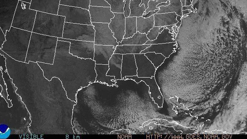
The accompanying satellite photo shows an excellent example of ocean effect conditions. Clear skies over the mainland and plenty of cloud cover over the ocean – and seashore communities. That would be us.
 |
| NOAA |
So if you happen to be operating over the Atlantic waters this Fall (or Spring) when a particularly cold air mass follows a cold front, be aware that despite forecasts of clearing, windy and colder conditions, it is very likely that considerable clouds will be experienced offshore, with the real potential for serious rain, or snow, at times.
BTW, if you are interested in being part of USCG Forces, email me at JoinUSCGAux@aol.com or go directly to the US Coast Guard Auxiliary “Flotilla Finder” at http://www.cgaux.org/units.php and we will help you “get in this thing...”
